The rectangle of the estimated fault model, whose top edge is 4km under the ground, is at an angle of 81 degrees from the horizontal (nearly vertical). The rectangular fault is 11km wide and 12km long with a strike of 275 degrees clockwise from north (nearly in the east-west direction).
The hanging wall (north side wall) of this fault plane moves 50cm downward at an angle of 19 degrees from the horizontal, relative to the footwall (south side wall).
In the future, we will estimate a more precise fault model.
Table1*: According to the data by the 124th Coordinating Committee for Earthquake Prediction
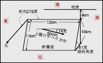
3-dimensional geometry of the estimated fault model
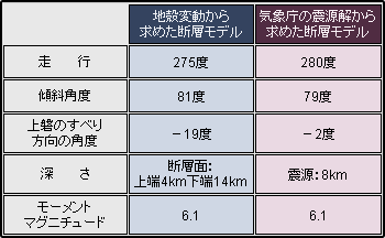
Table1) Comparison of parameters between the fault model estimated from the crustal deformation
and the hypocenter solution* provided by the Japan Meteorological Agency
