Also see "Crustal Deformation and Source Fault of the Sichuan (Wenchuan) Earthquake in 2008", GSI Geography and Crustal Dynamics Research Center Topics.
China Sichuan Earthquake (2008/5/12,Mw7.9)
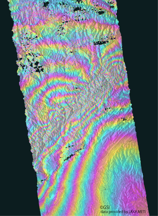
How to understand the SAR interferogram
| No. | Interferogram | Specifications | Comments | Down load |
|
|---|---|---|---|---|---|
| 1 |
|
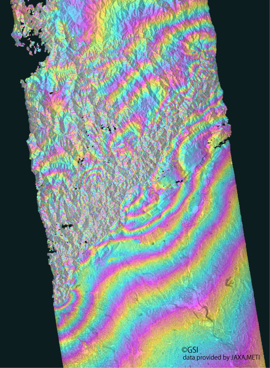
Observation date | 2008/02/17 2008/05/19 |
The obvious crustal deformation caused by the earthquake appears.
*Accuracy of the used orbit data:High precision orbit data(2008.06.01 update). *Deformation could not be detected in the area where a sand colored pattern not a rainbow-colored fringes is drawn among white bordered regions in an interferogram. This means the deformation was too steep to be detected by the InSAR analysis. |
|
| Observation Mode | FBS/HH FBS/HH |
||||
| Orbital direction | Ascending | ||||
| Off-nadir [degree] |
34.3 | ||||
| Baseline[m] (Bperp) |
+217 | ||||
| Range (lat/lon) |
31.26/32.46/ 103.94/105.04 |
||||
| 2 |
|
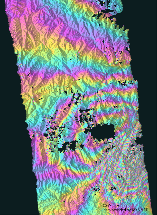
Observation date | 2008/04/08 2008/05/24 |
The obvious crustal deformation caused by the earthquake appears.
*Accuracy of the used orbit data:High precision orbit data(2008.06.01 update). *The DEM (Digital Elevation Model) data to use for analysis dose not exist in the area where an interferogram has no data. |
|
| Observation Mode | FBS/HH FBS/HH |
||||
| Orbital direction | Ascending | ||||
| Off-nadir [degree] |
34.3 | ||||
| Baseline[m] (Bperp) |
-196 | ||||
| Range (lat/lon) |
30.73/31.93/ 102.46/103.56 |
||||
| 3 |
|
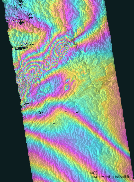
Observation date | 2008/02/29 2008/05/31 |
The obvious crustal deformation caused by the earthquake appears.
*Accuracy of the used orbit data:High precision orbit data(2008.06.01 update). *The influence of disturbance by weather, etc. may be contained. *The DEM (Digital Elevation Model) data to use for analysis dose not exist in the area where an interferogram has no data. |
|
| Observation Mode | FBS/HH FBS/HH |
||||
| Orbital direction | Ascending | ||||
| Off-nadir [degree] |
34.3 | ||||
| Baseline[m] (Bperp) |
+90 | ||||
| Range (lat/lon) |
31.75/32.95/ 104.90/106.00 |
||||
| 4 |
|
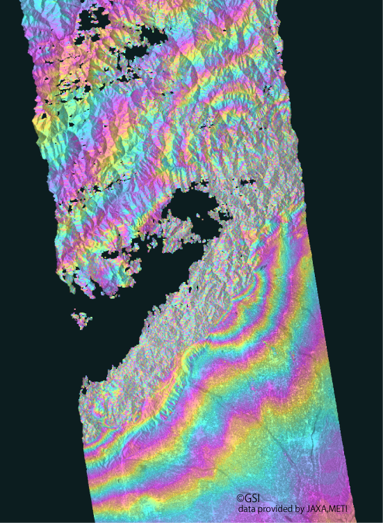
Observation date | 2008/03/05 2008/06/05 |
The obvious crustal deformation caused by the earthquake appears.
*Accuracy of the used orbit data:High precision orbit data(2008.06.01 update). *The DEM (Digital Elevation Model) data to use for analysis dose not exist in the area where an interferogram has no data. |
|
| Observation Mode | FBS/HH FBS/HH |
||||
| Orbital direction | Ascending | ||||
| Off-nadir [degree] |
34.3 | ||||
| Baseline[m] (Bperp) |
+283 | ||||
| Range (lat/lon) |
30.94/32.14/ 103.50/104.60 |
||||
| 5 |

|
Observation date | 2008/04/25 2008/06/10 |
The obvious crustal deformation caused by the earthquake appears.
*Accuracy of the used orbit data:High precision orbit data(2008.06.01 update). *The DEM (Digital Elevation Model) data to use for analysis dose not exist in the area where an interferogram has no data. |
|
| Observation Mode | FBD/HH FBS/HH |
||||
| Orbital direction | Ascending | ||||
| Off-nadir [degree] |
34.3 | ||||
| Baseline[m] (Bperp) |
-71 | ||||
| Range (lat/lon) |
30.70/31.90/ 101.95/103.05 |
||||
| 6 |
|
Observation date | 2007/01/28 2008/06/17 |
The obvious crustal deformation caused by the earthquake appears.
*Accuracy of the used orbit data:High precision orbit data(2008.06.01 update). *The DEM (Digital Elevation Model) data to use for analysis dose not exist in the area where an interferogram has no data. |
|
| Observation Mode | FBS/HH FBS/HH |
||||
| Orbital direction | Ascending | ||||
| Off-nadir [degree] |
34.3 | ||||
| Baseline[m] (Bperp) |
+203 | ||||
| Range (lat/lon) |
31.67/32.87/ 104.37/105.47 |
||||
| 7 |

|
Observation date | 2007/06/20 2008/06/22 |
The obvious crustal deformation caused by the earthquake appears.
*Accuracy of the used orbit data:High precision orbit data(2008.06.01 update). *The DEM (Digital Elevation Model) data to use for analysis dose not exist in the area where an interferogram has no data. |
|
| Observation Mode | FBD/HH FBS/HH |
||||
| Orbital direction | Ascending | ||||
| Off-nadir [degree] |
34.3 | ||||
| Baseline[m] (Bperp) |
-21 | ||||
| Range (lat/lon) |
30.75/31.95/ 102.98/104.08 |
||||