"Errors in the SAR interferogram?"
Principle of InSAR / Advanced Course1
When creating an interferogram of surface deformation by using InSAR, it is not always true that an interference pattern (fringes) of an initial interferogram shows surface deformation directly. This is because the difference in phase between two observations is influenced by things outside surface deformation.
What is contained in a SAR interferogram
Influence other than surface deformation are contained in the difference in phase between two observations. They are two kinds of fringe which are generated because two satellite orbits are not exactly the same, (a) one is called orbital and topographic fringe and has roots in the difference between two orbits and topography, (b) the other has roots in a spacial disturbance of propagation delays occurred in the ionosphere, the troposphere, etc.. So we need to remove these fringes from the initial interferogram to obtain surface deformation. But if the method for removing them is not correct, the measurement of surface deformation is in error.
For orbital fringes in above (a), because a fringe pattern is exactly reproduced by using position relation between satellite orbits at two distinct times (baseline length) and the location of a target on the ground, they are corrected by using this fringe pattern.
And for topographic fringes, if digital elevation data (DEM) of a target area are available, they can also be corrected by geometric computation.
GSI 50m DEM covers all over the area of Japan and has enough accuracy and resolution to detect surface deformation by InSAR at present. This technique for removing topographic fringes is called a 2-pass method because of using two SAR observation data.
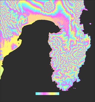
Figure 9. Topographic fringes
Even if DEM is not available, correction can be performed by using topographic fringes created from another pair of SAR interferograms in which the surface does not deform or deforms with a constant rate. This is called 3-pass or 4-pass method because of the number of required SAR data.
In this way, to remove topographic fringes from a SAR interferogram it is necessary to get the difference between SAR interferograms or between a SAR interferogram and simulated InSAR topographic fringes which are generated from DEM. So, InSAR is also called differential SAR interferometry. If the baseline length completely vanishes, topographic fringes also vanish. But the baseline length cannot really vanish, so the InSAR for detecting surface deformation is a kind of differential SAR interferometry from the fact that topographic fringes are removed by a difference method.
To detect surface deformation with centimeter precision, it is necessary to measure the baseline length with the same precision. However, trajectory information of a satellite often has a margin of error of more than 100 meters. To completely remove fringes described in above (a), lots of technical know-how, such as estimating the baseline length from phases of a interferogram of a area where elevation data exist, are needed.
For the influence of the ionosphere described in above (b), simultaneous observations by the L-band and C-band radar of SIR-C (Shuttle Imaging Radar C, SAR observation by the NASA Space Shuttle in orbit 220 km above the ground in 1994) are free from this influence. However, because SAR satellites travel at higher altitude than SIR-C, it seems that the influence of the ionosphere exists.
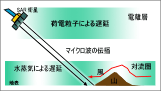
Figure 10. Error sources in propagation process(b)
In addition, the propagation delay caused by the disturbance of water vapor in the troposphere is very large, so it lead to problems as errors contained in an interferogram. It is also said that a vegetation change, a change of reflection points of volume scattering waves due to the variation of soil water content, etc. cause errors. However, above (a) and (b) are the main sources of errors at present.