Nevada Earthquake (2008/2/21,M6.0)
How to understand the SAR interferogram
| No. | Interferogram | Specifications | Comments | Down load |
|
|---|---|---|---|---|---|
| 1 |
|
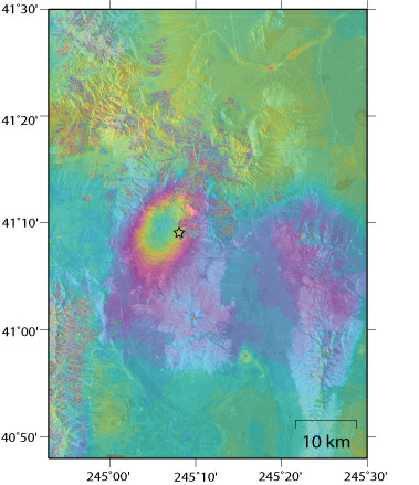
Observation date | 2007/12/19 2008/03/20 |
The crustal deformation caused by the earthquake appears near the seismic center. The maximum Line-of-sight (LOS) displacement far from the satellite amounts to about 10 cm. |
|
| Observation Mode | FBS/HH FBS/HH |
||||
| Orbital direction | Ascending | ||||
| Off-nadir [degree] |
34.3 | ||||
| Baseline[m] (Bperp) |
+826 | ||||
| Range (lat/lon) |
40.80/41.50/ -115.12/-114.50 |
||||